Friday, October 21, 2016

California's Best Ghost Town -- Bodie


The old mining town of Bodie is as close to the middle of nowhere as is possible.

From the well-traveled Highway 395 that runs North and South along the backside of the Sierra Nevada Mountains, you hang a sharp turn to the East from a canyon where Washoe Indians once lived in relative isolation. You climb high into the barren hills to get there.

The road into Bodie, part paved and part gravel, snakes past Basque shepherds watching hundreds of sheep, and barren hills with no fences.

The "Main" road into Bodie wanders its way across the hills
In 1859 the isolation changed. A miner from New York state named W.S. Bodey discovered gold. He died in a blizzard that winter and his bones were lost 20 years  later, probably buried on the hillside above the remnants of the town. The town is named after him, misspelled name and lost bones notwithstanding.

The big strike happened in 1875 when a mine collapse revealed a rich seam of gold. Within a few years  up to 8,000 people lived in this place, and 30 mines and nine stamp mills were operating around the clock. The 60 saloons and whore houses stayed busy.

The noise must have been awful, with the stamps pounding the quartz rock around the clock. And the fights and the shootings which were commonplace.

In 1942, as part of the effort to concentrate work on winning World War Two, gold mining was shut down, and what was left of the town dried up completely.
Tourists on Main Street Bodie, schoolhouse on the right and the church at distant left


Today, the gold miners, the Washoe and their families are all gone. But Bodie is still there, About five percent of the original town remains, a state park, protected by park aides, isolation and a few repaired roofs.

Booms, busts and fires and a history-minded land-owner provide what is left today, the best preserved "ghost town" perhaps in the world. Every great photographer in the West comes here, along with a steady stream of  tourists in RVs and rented cars. In bad weather -- which is most of the winter -- the caretakers have it all to themselves, except for the occasional snowmobile riders.

You can find much more at www.parks.ca.gov/bodie or www.bodiefoundation.org

California has many great parks. Bodie is unique, and worth the trip.


The last stamp mill on the hill above town. At one time there were 30 mills operating here.


An abandoned bedroom in one of the finer houses in town -- ghostly photographer


The dry desert air helps preserve the interior. Not comfortable in winter.


Imagine how cold this "two-holer" outhouse would be when winter winds blow snow through cracks.

The backside of the Sierra about 15 miles away  is visible across the hills to the west.

The last residents left in the 1930s, but some homes survive from the 1800s.


Most of the wooden construction burned, but the hotel and bar and a few others remain.

The views were spectacular and the lawn never needed mowing.

All around the "bowl" in the hills that Bodie sits in are tailings from the mine workings.

Photographers love the abandoned implements left lying around.
The "welcome mat" is always out at this home.

The truck dates from the 1930s, when people pulled out and abandoned the town. More mine tailings on the ridge.

Not the most hospitable place in the world.
The church has weathered well.
The old powerhouse, built when electricity arrived at the turn of the century.

Bars and places to eat collected a lot of the miners' money back in the day.

Side trips in the area should include driving South on the "bypass road" also known as Cottonwood Canyon Road, which leads to the north edge of Mono Lake. The lake is a spectacular salt-water body of water tucked up against the mountains, adjacent to the access to Yosemite National Park from the east (except in winter).  The drive along Highway 395 is one of the best places to see Fall colors as the Aspen change and the landscape becomes even more fascinating.


Sanders LaMont
October, 2016


Thursday, April 14, 2016

Yosemite in Spring

Yosemite National Park -- A mid-week visit to Yosemite in Spring, when the weather is good but not perfect and the tourists are present but not overwhelming,  ranks among the great benefits of living in the nearby Sierra Nevada.

Our day trip took about three hours of no-traffic driving from our front door.
Spring is about many things, but is obviously is about waterfalls.


The first waterfall we encountered on the Big Oak Flat Road was the Cascades. The actual fall is up the mountain and obscured by trees and boulders, but the water below the bridge is a sight to behold.


A little further down the steep road, which clings to the mountainside as you descend into the Valley, are multiple views of the Merced River in full flow through the Valley. Bridalveil Falls is in the distance, spilling out of its hanging canyon high above the south wall of granite.   It is only 620 feet above the canyon floor, about one-fourth of the popular Yosemite Falls, but can offer some of the most spectacular viewing when the wind is blowing back against the crest.


Further down inside the Valley you begin to see falls, on both sides of the canyon. We did not get pictures of them all, obviously, as some are more subtle than others, and some beyond this photographer's ability.


Here is one of our first views  of Yosemite Falls, which looms 2,425 feet above the bottom where it crashes into the rocks and flows into the Merced River.  From this distance you only see the top of the waterfall. This was taken as we drove in, shot from near the loop road on the South side of the canyon.  You can see Spring popping out in the greening trees and grasses, and the still bare branches just waiting for a few more warm days.


Below are two ribbon-like falls just above Curry Village on the south wall.  The sound of water flowing is everywhere you turn, whether crashing off the top of the walls or cascading down the talus slopes. (Not far from here a large section of granite wall fell a year or so ago, scaring the heck out of people and slightly reducing the useable space in Camp Curry.)


At the upper end of the Valley you can look up toward Tenaya Canyon, and see and feel the power of the Merced River as if heads down the mountain. History note: this is one route the native Americans used when trying to run away from Gold Miners determined to wipe them out in the 1850s.


Coming back on the west-bound loop brings you to the trail to Yosemite Falls, the biggest and grandest of all in the park. This is one of the places you can see almost the entire waterfall, which actually comes down the mountain in at least three sections. A few weeks earlier the pool at the bottom of the top fall would have a large snow cone, but it apparently broke up before we arrived this week.


Here's a view from further away:


And here is what you see if hike up close: the bottom of the falls and a lot of cold blowing watery mist.


As we left the Valley we did what most tourists do: stop to look for mountain climbers on the face of El Capitan.  We forgot binoculars, assured each other those tiny dots on the granite were climbers, and enjoyed one last look at the Valley before driving home.


Go soon, before the crowds become intolerable, and while the water still flows.


Tuesday, March 22, 2016

Sailing Southwest Florida

West Coast of Florida -- March 2016-- Pat and I joined two friends for a one week cruise from Tampa Bay south to Boca Grande Pass, near Usseppa Island, and back. This is the part of the Florida coast just north of where we once lived, quite near Sanibel and Captiva.  We chartered a sailboat 41 feet long, with two cabins and plenty of modern amenities, for the trip which usually involved sailing or motor-sailing for about six hours each day. The total trip probably covered less than 300 miles, some offshore in the Gulf of Mexico and some inshore in the IntraCoastal Waterway.

The weather was warm, the winds mixed, and we encountered one day of serious fog offshore. Navigation was by GPS, partly using an App Barbara downloaded into her phone. We all met in Ohio in 1977 when John and I worked at the newspaper there. he now writes novels, Barbara is a marketing executive, and Pat and I are thoroughly retired.
.

A good time was had by all.


Day One


Here is the 41 foot Jenneua sloop we chartered for a week off the Southwest Coast with our friends John and Barbara Koenig of Austin, Tex. After a good dinner, we went to a local grocery store and bought supplies for the days ahead. Yes, there was rum on board.


Pat at the dock in the Vinoy Hotel Marina as we were getting ourselves ready to go.


Barbara and John in the cockpit at the marina.

Crew member standing by.


Day Two

Sailing out of Tampa Bay under the bridges, before turning left into the IntraCoastal Waterway for our first night's anchorage.


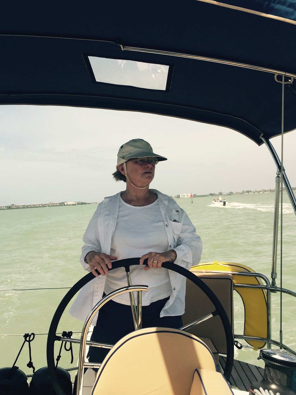
Barbara at the helm in the IntraCoastal.


John checking the news at anchor off the Mar-Visa Restaurant  at Longboat Key.


Pat chilling.


The anchorage on a sunny day.


We took our tiny dingy into the dock for a very good seafood dinner at the restaurant and met a friend of the Koenig's from Australia. Good company. 


Day Three


Next day we were southbound slogging into three foot swells with the wind on our collective noses.


Not sure which day, but this is inside the IntraCoastal Waterway

Pat at the helm.


Snack time.


Posed picture in the wind.

Day Four


We were reminded that Florida estuaries are shallow, and spent about an hour getting off a sandbar along the edge of the channel. The volunteers took our anchor out 50 feet or so, back into deeper water, and we kedged ourselves off when the tide came up. No harm done.


Time for a quiet sunset.


Sunset  at anchor off Usseppa Island, across the waterway from Cabbage Key. Pat and I had anchored here more than 15 years ago.

Day Five

Sailing south, as seen from the salon.


A little artsy photo work.


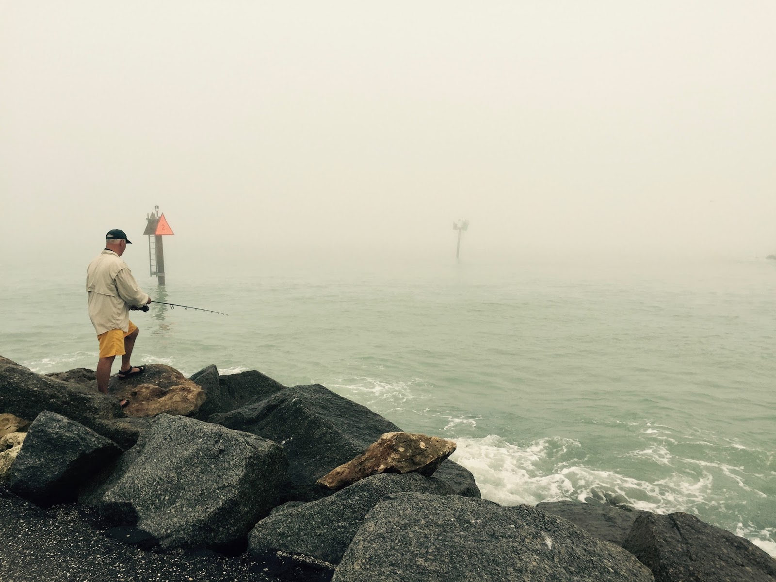
Day Six, after being offshore in fog all day long.


At the Crows Nest Marina after all day offshore in dense fog. Coming in through the pass and bridge was a challenge well met by experienced companions and good electronics. Visibility was down to less than 100 yards at times.

This is the pass to the Gulf of Mexico we navigated through.


At the dock, safely. Dinner in the pub.


Day Seven

Next day an easier trip up the waterway  into an anchorage south of Tampa Bay.

One more night view.


Pat being happy.


Barbara being happy.

John being happy.


Our last anchorage was at DeSoto Park tucked inside away from the worst of the fog.


Checking with the home front. We learned how very versatile our phones were.

Our Last Day Aboard

 
Last day we went back into Tampa Bay for the final miles home.


===================


 Below is how we did dinner on the boat. We stocked the boat with supplies to do all but about three meals, when we knew we would be near a good place to eat.


Barbara planned a couple of quick fix meals, which were delicious.


Might as well have a nice red wine with dinner.


The menu this night was ham, pineapple, yams and fresh corn.

The view was pretty good

As was the red wine.


==================

As we approached St. Petersburg on the last day, this boat came out to greet us.


A great vacation. We would do it again.